Saturday, November 29, 2014

Cat Bells, Maiden Moor, High Spy

looking down onto Cat Bells

We had an early start today as I needed to be home for 10.30am. I set off from home at about 6.30am and we were running just after 7am.  We needed head torches at the very start but had turned them off and packed them away after the first of the two main steps on Cat Bells.

We parked at the usual spot just over the cattle grid on the road to Skelgill and then went the usual route up Cat Bells and over.  There were great views as the sun rose, the anticipated cloud inversions seemed to be happening over towards the Dodds and maybe deeper into Borrowdale.

We carried on up over Maiden Moor to High Spy.  Here, with an eye on time, we decided to drop down through the old Rigghead Quarries, peering into some mine openings but not chancing going in further.

This way down took us onto the Allerdale Ramble track which we followed to the road and then took the road for speed due to time limitations.

Nice morning run out.

a dark start

Keswick waking up

from High Spy looking over to Dale Head

one of the many mine entrances at Rigghead Quarries

back on the Allerdale Ramble track passing Castle Crag on the right


Wednesday, November 26, 2014

Hardly AC - Dodd

David, Jonathan and Alastair (I think) on top of Dodd

A bit of last minute organisation and we managed to get a group of seven together for an evening run around Dodd at Bassenthwaite.

The first mile is uphill and it's a test of pacing - all about getting into the slow uphill rhythm.

It levels out for a bit before winding up to Dodd summit.


What goes up, must come down and, after an initially steep descent, the gradient becomes much mellower and breezy as you sail downhill for a couple of miles.

Four and a half miles but including a good hill test.  This is a great, easy to follow, winter route on good ground.

Good to get out on a dark cold night.  Ideal running conditions if you ask me.


Sunday, November 23, 2014

Four Lakeland Passes

Paul and Jonathan heading towards Buttermere along the old mine track over Honister Pass

A testing run today.  I woke up with a sore heel.  Plantar Fasciitis hurts the most in the mornings as your foot has been relaxed through the night.  A bit of walking around and stretching it out made it feel a bit better but I was still a bit nervous about taking on today's route, a reverse of the classic four lakeland passes route.  It's a Long Distance Walkers Association route, usually starting from Rosthwaite.  There used to be an event every year but we don't think it has been put on for a few years.

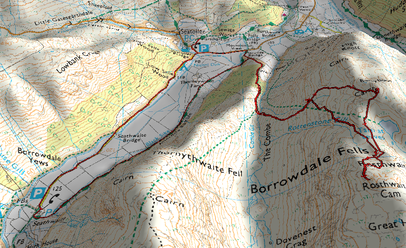
Our route started at Seathwaite Farm, we went along the road to the car park at Seatoller and took the track through the car park which meets up with the bridleway that runs alongside the road up to the Slate Mine.

I got my running sticks out here, something I was trying after winning them for getting a photo in Trail Running Magazine.  I thought it might make it a bit easier on my feet too.

Through the slate mine and we took the straight and direct old mine track over to Dubs Bothy and then down the really rocky track to Warnscale Bottom and along to Gatesgarth Farm.  We ran along the bottom of Buttermere Lake and then started the climb up Scarth Gap Pass.

Honister Youth Hostel and the slate mine
We had a little run along the top before picking up an initially muddy and then a nice track down the other side into Ennerdale and on to Black Sail Hut.  We were planning to refill water bottles here but saw that the hut is closed for the winter.  Paul filled his bottle up from Sail Beck - he needed to after swallowing a fly in Ennerdale.

We passed by the famous gate mentioned by Wainwright at the top of Black Sail Pass and then headed down the long descent into Wasdale.  Jonathan and I filled up on water from Gatherstone Beck at the point where the track crosses over it.

Down at Wasdale Head, Jonathan and I had a can of coke each and then we had an easy walk up the front of Great Gable to Sty Head.  I was tired at this point but not as tired as the last time I had a go at the route.

The path down to Stockley Bridge is rocky but I find that kind of terrain pretty good to run on and I was feeling good, really happy that my heel wasn't hurting.  Down at the bridge, it was just an easy mile or so back to the car.

Really really happy to get a decent distance in without any real heel issues.  The longest run I've done for a bit.  We celebrated with a pint in the Scafell Hotel.

heading down the very rocky path to Buttermere

our path down into Buttermere can be seen on the right hand side of the picture, starting from the corner and winding along Warnscale Bottom parallel to the beck on its left.  There is a group of trees on the near left side of the lake.  These are at the start of the climb back up this way over Scarth Gap Pass.

topping out on Scarth Gap Pass with cloud hanging over High Crag

heading down into the shadow of Ennerdale

top of Black Sail Pass and the famous gate mentioned by Wainwright

Paul heading down the other side of Black Sail into Mosedale

now at Wasdale, the track up the front of Great Gable is just visible in the centre of the picture.

Jonathan trides out the sticks.  The flat fields behind are at Wasdale.

passing Styhead Tarn

down at Stockley Bridge.  Seathwaite Fell behind.

Jonathan and Paul coming along the track back to the farm.

route elevation profile

route.

Friday, November 21, 2014

Dodd

Jonathan on the way back down, the lights of Keswick ahead

Dodd summit
I got a call from Jonathan in the middle of the afternoon, "Have you seen the weather? It's absolutely tipping it down, what do you suggest?"

"I suggest you wear a jacket" was my reply.

We had planned to run up to Dodd after work and then possibly on to Skiddaw.  The rain had subsided a bit when we got to the parking spot.  There is an immediate climb, for a mile.  I managed to run all the way up the climb but then I was pretty much done.  It wasn't a difficult argument to just stick to Dodd.

Jonathan ran off ahead up the path and I tried to take short cuts up the grass.

We have worked the head torches out now and know how to ensure it is on the setting which means that the battery doesn't burn out after an hour and a half.

After a couple of pictures at the top, we had a gentle run down.  I was feeling that Hoka knee and hip strain that I know from longer fell runs and Jonathan is quite happy taking it easier down hills.

By the time we had got back to the car, we had covered about four and a half miles.

Quite happy with that.


Saturday, November 15, 2014

Bessyboot

from Bessyboot cairn looking onto Tarn at Leaves

after crossing Coombe Gill looking back to Borrowdale
There is a route in Borrowdale from Bessyboot, along to Glaramara and on to Allen Crags.  I've tried before to take this route and, like today, turned back due to low cloud.  I really wanted to practice some map reading today and did pretty well, starting from Seatoller car park, along the road to the farm track opposit Mountain View towards Thorneywaite Farm.  I took the track up to the left after the first wall.  This follows the wall and then runs alongside Coombe Gill which I had to cross to carry on up towards Bessyboot.
Rosthwaite Cam through the cloud 
I followed the gill up to where the land levelled out slightly before crossing a few undulating bits to pick out the summit.  The cloud, which I had hoped would burn off, was still sat heavily over Glaramara.  From Bessyboot summit, I picked an easy path down to the wonderfully named Tarn at Leaves and then, followed a track which took me to Rosthwaite Cam, which is higher than the top of Bessyboot which Wainwright chose as his summit.
top of Rosthwaite Cam

just me and a lot of cloud up here
From the top of Rosthwaite Cam, I had a look around and saw nothing but cloud.  I know Glaramara to be a confusing to navigate Fell in fair weather and didn't much fancy heading over and getting lost in the boggy top so I headed back the same way, enjoying an easy descent back to the farm track.  I had a run along to Seathwaite and back along the road and noted a track to check out the next time I head this way which seems to avoid the road and might go past the famous Borrowdale Yews, thought to be 2000 years old.


Wednesday, November 12, 2014

Ullscarf

Ullscarf in the wind and rain
I had a day off today.  The weather wasn't great but I was keen to get out.  I headed to Stonethwaite with a plan to head up the windy path of Lingy End and then head over to Ullscarf and back the Greenup Gill path.  It stayed dry to Dock Tarn and then the heavens really opened.  I seem to remember that the conditions were a bit difficult the last time I was up here.

At the start, Eagle Crag's distinctive profile with Greenup Edge in cloud

at the top of the initial climb looking back over Langstrath

Dock Tarn

looking back, cloud very low

wet top of Ullscarf
I had in my mind that I needed to go over High Crag and follow the wall.  Looking back at the route I took, this was the correct strategy but I should have turned along the wall rather than going all the way to the tarn.

I used the sophisticated navigation technique of keeping going as long as I was heading to higher ground for the next mile or so, picking up the junction of fences at the top.

Ullscarf summit looks on the map as though it is along a fence line.  It is actually an old fence with just a series of iron posts still in place.  These made handy navigations tick points as I continued on the path along to Greenup Edge.

There is a shortcut track from the main track which allows you to cut the corner off.  I managed to pick this up and then followed the cairns down past Lining Crag on a treacherous, particularly so when wet, pitched path.  There are several Gills to cross.  I didn't waste time by trying to find a dry way across and eventually got onto the track back to Stonethwaite.

dropping back down below the cloud

on better ground now, heading back to Stonethwaite


Sunday, November 9, 2014

Great Gable Remembrance 2014

hundreds of people on top of Great Gable ready to pay their respects

We started off today with a two mile or so walk up to Great Gable for the annual remembrance ceremony on the top.  We tried to find a balance between leaving plenty of time and not being stood around on the top getting cold.  Ultimately, we set off a bit early so we dawdled a bit on the ascent and still got to the top a good half hour early.  Next year 9.30am from Wasdale Head.

After a short speech and two minutes of eerily quiet reflection, we retraced our steps to Beck Head where we picked up the little track that goes around Boat How Crags to Black Sail Pass.  This is just the type of running I like, rocky and technical without too much of a climb.  We met up with the track up to the famous gate on Black Sail Pass and then decided to head down Black Sail Pass back to Wasdale rather than carrying on climbing to Pillar which was in cloud.

The run down was great fun, wet and rocky, a winding path with grassy run off bits.  A few of us took tumbles but we seemed to land back on our feet.  About 6.5 miles, a nice run out.

Great Gable in cloud as we set off from Wasdale Head

at Beck Head, trying to pace ourselves a bit.  View down to Wast Water

clearing a bit, Haystacks over the valley.  Beckhead Tarn below where we will veer off to the right around Kirkfell on our return journey.

plenty of people at the top

Lucy had been waiting a while

Dean bagged another Wainwright

around Boat How.  That's Loft Beck over the valley, steep descent taken on St Bega's Ultra

into the valley floor and easier running


I had suggested running over Pillar and around to Dore Head scree.  It looks very steep from here.  That's mostly because it is although it's quite do-able.

this track takes you right back to the bar

post run cool off/shoe wash